A complex environment within the active monsoon trough over the Samoa Islands keeps the possibility of a tropical cyclone development.
The National Weather Service expects the following threats to remain by at least Tuesday: damaging winds, heavy precipitation, flash flooding, rough seas and dangerous waves.
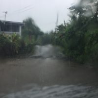
Aoa Road this morning
CURRENT Watches, Warnings, Advisories:
• Gale Warning
• High Wind Warning
• Flash Flood Watch
• High Surf Warning
Impacts:
• American Samoa Waters:
*Gale force winds will continue this weekend and into the first half of the upcoming work week.
*Current conditions for rough seas report 15 to 18 feet (translates to surfs of up to 20 feet). Seas will then peak tonight to 18 to 21 feet (surfs up to 26 feet) through Tuesday.
*Very rough seas and damaging heavy swells could capsize or damage vessels and
reduce visibility.
*Possible coastal inundation especially during high tides.
• Winds:
*Strong west to northwest winds 35 to 46 mph today. We anticipate the worst winds
by tonight into Monday, possibly reaching 65 mph with much higher gusts due to
downslope winds.
*Strong winds will make driving difficult. Expect power outage from downed power
lines, blown down trees, loose and unsecured objects, damage roofs, small out- buildings, tents and outdoor kitchen.
• Rain:
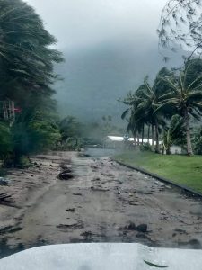
*Flash Flood Watch remains in effect. Periods of locally heavy rainfall would pose a threat to flood prone and low lying areas. Flash flooding conditions are possible Saturday through the new week.
*Heavy rainfall and squally thunderstorms can reduce visibility, cause landslides, and make driving difficult.


